By Remígio Chilaule, Universidade Eduardo Mondlane; Abneusa Stefania, MozDevs; & Bontje Zangerling, The World Bank

Maputo aerial view (www.casasmelhoradas.com)
Like many sub-Saharan African capital cities, Mozambique’s capital Maputo has all the marks of a city whose rate of growth surpasses the ability of its urban systems to cope and respond. The tell-tale symptoms include: ever-expanding suburbs of mostly residential and micro-scale commercial uses and insufficient infrastructure; increasing traffic congestion and incapable public transport systems; increasingly dense and disordered land use; among others. This scenario leaves communities in many neighbourhoods exposed to public health problems and vulnerable to natural hazards, particularly flooding.
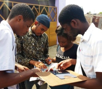
To face these challenges and work towards more resilient settlements, a community mapping pilot project was launched in the Greater Maputo Area with support from the World Bank and GFDRR. The project aimed at learning and adapting a data gathering methodology that could provide critical information about risk, at a low cost. The methodology was informed by the on-going Ramani Huria project in Dar-es-Salaam, Tanzania, as well as Open Cities Asia; it pairs university students with residents of the mapped areas and equips them with knowledge and simple tools to collect and digitize data. This data is subsequently made fully accessible on OpenStreetMap.org (OSM), a global database for georeferenced information about the planet. The data was processed to make it more accessible to decision makers directly concerned with risk reduction, in particular Mozambique’s National Disaster Management Agency (INGC) and the municipal and local authorities.
Final maps of pilot neighbourhoods
The project tested out the methodology in two neighbourhoods: Hulene-B in Maputo, and Acordos de Lusaka in Matola, totalling close to 8 km² of dense low-income settlements. Between February and June 2017, more than 40 students and activists worked with residents to collect detailed data about their neighbourhoods. Fine-grained data includes over 40 km of narrow inner alleys, about 65.000 m² of wetlands, and more than 220 homes built in and around them.
The vast amount of detailed data collected was not the only impressive result of the project. Another equally important outcome was the successful adaptation of the Ramani Huria experience to a fully-tested Mozambican version of the methodology, capable of being replicated in similar urban contexts across Mozambique.

Another result was the ‘arrival’ of the discussion on open data to the Mozambican institutional and social context, which is best exemplified by the interest and willingness to collaborate demonstrated by INGC, Municipalities and public university (all direct partners of the pilot), and by the emergence of a community of enthusiastic volunteer mappers. Of course, a lot of data has been produced for the two pilot neighbourhoods (including high quality drone aerial imagery for one of them) which sets a standard pushing other areas towards creating the same resource in urban management for resiliency.
Towards the end of the project, three members of the team and partners were granted GFDRR fellowships to attend a five-day training in Kampala followed by the three-day State of the Map Africa (SotM Africa) – the first time the landmark mapping conference was held on the continent. The training allowed the team to synthesize all the technical knowledge acquired throughout the pilot (using JOSM), and learn new skills in open data analysis for disaster risk management (using QGIS and InaSAFE). During SotM, the Mozambican delegation got the opportunity to present their work and interact with mapping communities from all over Africa and the world, sharing lessons learned as well as challenges, opening new avenues for the future of community mapping, not only for Mozambique but also for the OSM community as a whole.
This inspiration and information has helped to further motivate the mapping activists who have since started mapping a third neighbourhood in Maputo, under the Humanitarian OpenStreetMap Team micro-grant program. A group of civil society institutions has also taken up the methodology and are currently volunteering to open up existing public transport data by putting it on OpenStreetMap.
Ongoing mapping, beyond the pilot

The continuation of these mapping activities has been fuelled by grassroots efforts toward a vision of making community mapping common practice, understood as a simple act of citizenship. The pilot project has been an important first step toward that vision.